Throughout my journey of sorting through images, records, and writings to learn more about our homes in La Alma Lincoln Park, I have enjoyed many revelations that brought new meaning to our neighborhood’s significance to Denver and to Colorado. One of my first lessons was understanding a bit of our street names’ history. Through a seeing names on a simple map, a scene can be evoked – like with Bear, Buffalo, Moose and Deer (today’s 8th to 11th Avenues). It was also very useful to know how “Zuni Street” once served as “First Street”- while aligning with the Platte River, which helps explain our twisted downtown grid. A world of records opened up to me when I understood that our house on “Kalamath” once stood on “South Eleventh,” and it seemed significant that the West Denver horsecar rail line connecting to Larimer Street via Eleventh in Auraria ran down our street.

Robinson’s Plate 26 1887. Courtesy DPL, Western History Collection C978.81 R562at 1887
Many stories I have shared through this blog have tried to paint a picture of what life was like here in Denver’s frontier days, when Governor A C Hunt‘ s homestead “Cloverside,” was a remote estate. I have come across a brief article, written by Simpson T. Sopris*, a respected member of Denver since arriving with his father in 1860, and published in The Colorado Magazine by The Colorado Historical Society, entitled “Santa Fe Drive,” Denver , which more clearly illustrates how La Alma Lincoln Park developed from the earliest settlements in Auraria and Denver.

[Denver from Highlands] [art original]. Creator(s) Frenzeny, Paul. Tavernier, Jules, 1844-1889. Is Part Of Denver Public Library Western Art Collection C58-2
Mr Sopris emphatically refutes this revision to the history he witnessed,
“There was little travel in the early days between Denver and Santa Fe, New Mexico, and no direct road connected the two towns. The only wagon road running southward entered Denver by way of Ferry Street, in later years changed to Eleventh. Ferry Street was the first street, going from East Denver westward, that ran through West Denver from Larimer Street to the southern limits of the townsite, without running into the Cherry Creek. Hence, to get to the road leading to the south, you had to go over to Ferry”

Denver, Colorado, 1874 Courtesy Denver Public Library- Western History Collection CG4314 .D4 1874 .G53b Creator(s) Glover, E. S. (Eli Sheldon),
Readers of this blog may remember that the bed of the Cherry Creek was not always bounded by walls and Speer Boulevard. It was wide enough for the Denver Circle RR to run tracks through it from Larimer St to today’s Inca Street.
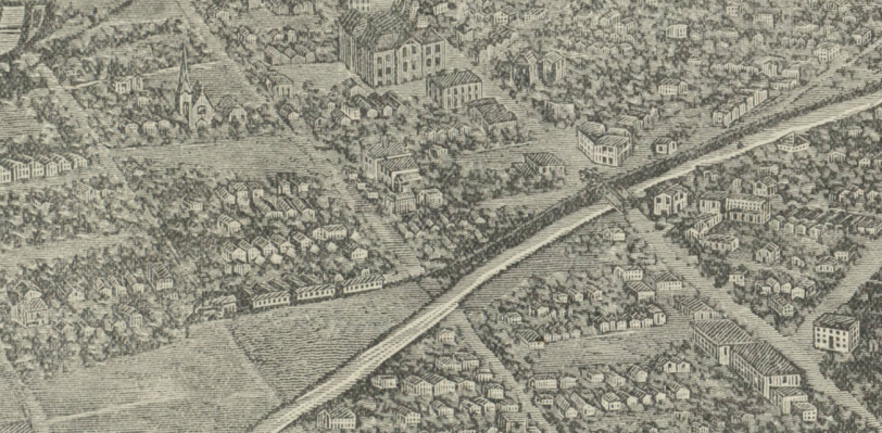
Bird’s-eye view of Denver, 1887. Created by Rocky Mountain News. Courtesy DPL Western History Collection CG4314.D4 1887.R62
“On the original map of Auraria, Ferry extended several blocks beyond …West Colfax, but the ‘built up’ part of the street did not go beyond the line of the ‘Congressional Grant’ (West Colfax), and from the occupied end of the street the road southward…followed a course closely parallel to the present Kalamath Street. But the road never dropped into the Platte River bottoms; it kept on high ground till it reached far enough to the southeast to avoid the gullies, or hollows, caused by water draining into the Platte from the higher ground; then , following the bend in the river, it turned to the south and ran midway between the present Broadway and the river.”
I was also aware of a little disagreement relating to “Santa Fe Drive” and it’s brief time as “Jason Street” In Denver Streets, Phil Goodstein describes the invention of our current “Indian Streets” system. Developed in the late 1890’s by a Denver Union Water Company bookkeeper, Howard C. Maloney, to assist in locating it’s customers, he thought the “J” names “Jicarilla” and “Jemez” lacked the English hard “J” sound. Oddly, he chose “Jason” from classical literature to describe the road between “Inca” and “Klamath” (apparently a signmaker’s error we just went with).

Denver, CO- 1907 Courtesy Denver Public Library Western History Collection Call Number CG4314 .D4 1907 .C5 Title Denver, Colorado Creator(s) Clason, George S. (George Samuel), 1874-1957. Date 1907
Citizen’s hated the Maloney system for many reasons, and stubbornly refused to use the new names. In Gene Fowler‘s most autobiographic novel, A Solo in Tom-Toms, he humourously describes the “controversial matter”:
“Sometime during 1903, a civic meddler had prevailed upon the officials to rename the streets west of Broadway in alphabetical order. The smug innovator had intended to deal in similar fashion with the streets east of Broadway, where dwelt the rich and influential personages of Capitol Hill. However he dared not molest the avenues that bore the stalwart names of Lincoln, Sherman, Grant, and Logan.
The renominator of streets had his way with the westsiders, who lacked the implements of political favor. We saw new signs take the places of the long-familiar boards along Tremont, Water, Evans, and other thoroughfares. It was as if part of the town were being remarried to a multitude of stepfathers…Many regarded it as an atrocity.
Grandpa, of course, objected to this tampering with the street names. He was infuriated by the fact that most of the new street names were Indian: Acoma, Bannock, Cherokee, Delaware, Elati, Fox, Galapagos, Inca…
As long as we’re remained in the neighborhood, Grandpa declined to recognize the change of our street’s name from South Tweflth to Fox. At the polls, he insisted upon being set down as a South Tweflth Street voter. His mail frequently was delayed at the post office for readdressing or strayed for weeks”

Robinson’s Plate 26 1887. Courtesy DPL, Western History Collection C978.81 R562at 1887
In 1912, residents won their protest, and Santa Fe Drive was officially renamed.

Jason Street to be Santa Fe Drive- From Denver Municipal Facts 1912 April 27. Courtesy DPL Western History Collection C352.078883 D4373mu
Mr Sopris maintains that despite claims of residents and property owners, if you were heading north to Denver, Santa Fe Drive would have run into the creek:
“There never before was a road leading out of Denver that was known by that name….For a road from Santa Fe or anywhere to the South to have followed the alleged “Santa Fe Drive” it would have had to cross scores of gullies, ravines, arroyos to get down into the river bottom and out of it, and when it got within about two blocks of present West Colfax it would have ended in the very sandy bed of the Cherry Creek. For, be it known to the ‘pioneer’ of 1880, more or less, the bed of the Cherry Creek, not the stream, extended far “inland” at that point, and a goodly part of the block of ground now covered by the county jail and criminal courthouse, as well as the fire engine house, was for years after Denver was put on the map, a part of Cherry Creek’s sandy bed.”
While maps seem to confirm the Mr. Sopris’ assertion that Santa Fe was not the likely connection to the Santa Fe Trail, I haven’t found any record that calls it anything other than “Santa Fe Street” before the “Jason Street” dust-up. It very clearly had developed into a vibrant commercial corridor which served our neighborhood by 1913 , as pictured below.
This first-hand account of how we developed in the past has significance for our neighborhood’s future. As the new Santa Fe Business Improvement District (BID) lobbies the city for wider sidewalks and traffic calming measures, and citizens are exploring opportunities to preserve and promote our unique character with potential historic districts, finding some reality through the mythology might help us find a way to move forward.


* From The Real Pioneers of Colorado by Maria Davies McGrath
SIMPSON T. SOPRIS (1860)
Simpson T. Sopris, donor to Denver of the Sopris Gates and the Sopris fountain in the Rose Gardens at City Park, joined the great majority of his pioneer comrades, who have gone beyond the Great Divide, when he died at his home, 1337 Stout Street, Friday morning, August 9, 1928, following a month’s illness. The last appearance made by Mr. Sopris was in June at the annual picnic of pioneers at Elitch Gardens. There he met the small company of men and women who may be truly called pioneers, talked with them, lunched with them under the trees, enjoyed the old-fashioned dancing and music, and returned home to face toward death. Born in Aurora, Indiana, December 3, 1845, he came overland in a covered wagon with his father, the late Captain Richard Sopris, his mother, brothers and sisters, arriving in Denver April 23, 1960. With his brothers, George and Elbridge, the lad kept the home fires burning in the new settlement while his father, answering the summons of President Abraham Lincoln, went to war with the Federal Army. Unlike most of the restless youths of that day, he elected to remain in Denver, rather than roam the mountains in search of gold. Accepting an offer of a job in a newspaper officer, young Sopris thought for a while to follow journalism but later took up a commercial career, joining the J. S. Brown Mercantile Co., when his sister, the late Irene Sopris, married young Brown. Sopris donated the Sopris Gates at the south entrance of City Park in memory of his father, and later added the fountain in the rose garden as a memorial to his mother Elizabeth Sopris. Surviving are his brothers, George L., with whom he lived, and Elbridge B. Sopris, four nieces and four nephews, all of Denver.
RICHARD SOPRIS (1858)
Richard Sopris was born in Bucks County, Pennsylvania, June 26, 1813. He learned the trade of house carpenter. In 1858 he started West, going by stage as far as Omaha and then outfitted for the trip across the plains. He arrived in time to become one of the original shareholders of the town of Auraria. He spent the winter and spring prospecting. In April 1859 he located a claim and began mining on the newly discovered Gregory and Bates lode. He was married June 3, 1836, near Philadelphia to Miss Elizabeth Allen of Trenton, New Jersey. In the spring of 1860 he returned to Indiana for the purpose of bringing his family, consisting of a wife and eight children, to Denver. He was captain of Co. C. 1st Colorado Infantry. He was twice mayor of Denver. He represented Colorado in the first territorial legislature and helped draft some mining laws for the new Western settlements. He helped organize the 1st Regiment of Colorado Volunteers and fought with the regiment against the Indians at Glorieta Pass [north-central New Mexico], and attained the rank of captain. He also fought against the slender Confederate forces in Arizona and New Mexico.

Carbondale & Mt. Sopris, Sep. 1906 Courtesy DPL Western History Collection X-6781 View southwest over Carbondale in Roaring Fork River Valley, Garfield County, Colorado, includes scattered wood frame and brick residences and businesses among agricultural fields between the Roaring Fork and Crystal Rivers. The Carbondale depot is on the north bank of the Roaring Fork River, serving the Denver and Rio Grande and the Crystal River Railroad. Mount Sopris (12,660 feet) rises in distance with light snow on peaks.
